

Finding Safety in Technology
The City of West Hollywood EOC staff are making waves with how they use their Emergency Operations Center software in support of community events.
The City of West Hollywood, aptly named “The Creative City,” is getting creative with addressing their public safety needs. Boasting approximately 35,000 residents and 1.2 million annual visitors, West Hollywood, California relies on the precision and timeliness of their Emergency Operations Center to respond to an array of emergency situations, from gas leaks to road closures, house fires, and water main breaks.
West Hollywood’s Emergency Operations Center (EOC) wanted to do more than just map basic emergency response data – they wanted to visualize key assets and events throughout the city, track activities and assets in real-time, manage all key elements of events (emergency and non-emergency) through a common operational picture, and be able to quickly and effectively report information and activities to the executive team. Beyond the traditional EOC pre and post disaster functions, West Hollywood’s legendary Sunset Strip and Santa Monica Boulevard create a unique challenge for their Emergency Operations Center. This includes regular special events (such as the iconic West Hollywood Halloween Carnival), and waves of crowds that require more planning, organization, and insight to be effective. GIS afforded the tools needed to handle any type of situation.
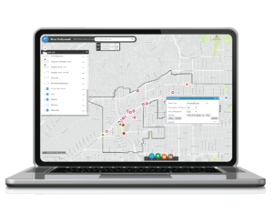
In 2017, West Hollywood’s EOC worked with Geographic Technologies Group, an Esri Gold Partner, to implement an innovative Public Safety Solution, SafeCityGIS. SafeCityGIS for EOCs utilized and adapted software that the City already owned as part of their Esri suite. GTG worked closely with City staff to set up the application suite and create targeted applications to meet the EOC needs. The centerpiece of the project was the use of the Esri Web AppBuilder, tailored to serve as the common operational picture for any event (emergency and non-emergency) and a GIS based executive dashboard to track key situational assets, events, and statistics. SafeCityGIS allows EOC staff to view pertinent data for any event in real time to include live input from field personnel via their smart devices.
SafeCityGIS’s GIS solution has given the City of West Hollywood’s EOC staff the ability to track live events in real-time paired with access to historical emergency information on their computer screens, allowing for better readiness, faster response, and ultimately a safer city for the entire West Hollywood community.
Eleazer “Lee” Hunt, Ph.D. former Director of Public Safety at GTG, believes SafeCityGIS is the answer to many GIS issues that EOCs experience. According to Lee, there “has always been a struggle to implement easy-to-use GIS tools for all levels of staff. SafeCityGIS harnesses the best GIS has to offer via an intuitive and very usable platform.”
For more information on West Hollywood’s EOC, or SafeCityGIS’s wide range of emergency readiness solutions, please visit the SafeCityGIS website:


