
The Most Rural County in North Carolina Implements GIS Technology
Hyde County, North Carolina is the second least populous county in the state has seen many boundary changes over the years. It currently boasts 1,424 square miles of territory — 811 of these square miles are water, including the largest natural lake in North Carolina, Lake Mattamuskeet. Hyde County is also one of the most rural counties in North Carolina, and County staff recognized that geospatial asset management would significantly improve operations.
 Geographic Technologies Group (GTG) was sub-contracted to work on Hyde County Water data back in June 2019 by Green Engineering of Wilson, NC. In September of 2020, following the creation of the County’s GIS Water network as a partnership with Green Engineering, Hyde County reached out to contract GTG directly for mobile GIS implementation, upgrades, support, and training services.
Before working with GTG, Hyde County did not have any GIS data available to show the location of water pipe infrastructure, and their teams referenced a hard-copy, hand-drawn map book to locate water assets. They found their field crews were spending a significant amount of time trying to locate assets, which hampered operations and efficiencies. The County realized a need to provide instant access to highly accurate GIS water asset location data for their field crews.
During the June 2019 partnership between GTG and Green Engineering, GPS-enabled Water Assets were imported into GIS and the County was assisted with creating a new database design. The consulting team also provided the development and attribution assignment of additional Water assets for the Hyde County water system. GTG imported GPS data from Microsoft Excel to GIS, referenced As-Built drawings, digitized water mains, ensured Water networks were topologically connected, and inserted attribution from the As-Builts.
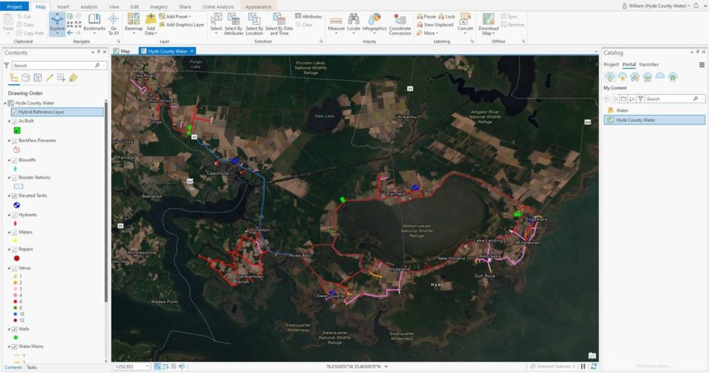
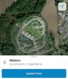
The final data deliverable consisted of a highly accurate Water feature dataset containing feature attachments. Once the data work was complete, GTG proposed the County purchase the appropriate Esri licensing to leverage Collector for ArcGIS for viewing and editing data in the field. The County elected to contract directly with GTG to receive the necessary GIS consulting and training services to get their field crews proficient with GIS and mobile access. The County’s Water data is now hosted in ArcGIS Online and the field crews leverage the Collector for ArcGIS and ArcGIS Explorer applications for viewing and editing data in the field.
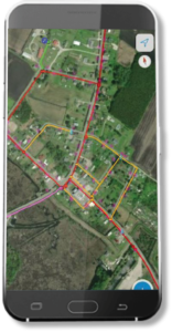
The County now has the data they need at their fingertips and is no longer required to rely so heavily on historical knowledge to locate Water assets and perform repairs throughout the water system. Having GIS data available remotely saves Hyde County field crews time and money. It also allows them to continue building out a detailed digital database of their water network and repair information.
Hyde County was set up for success with the GIS consulting and training services from Geographic Technologies Group. GTG published the Water data to the County’s ArcGIS Online account, prepared the data for use in the Collector for ArcGIS application, and developed Standard Operating Procedures (SOP) documentation on the Collector for ArcGIS app. Once the solution was deployed, GTG conducted onsite training with Hyde County’s field crew. The training covered how to work with and edit data in ArcGIS Pro as well as hands-on training on the use of the Collector for ArcGIS application. GTG now conducts as-needed hourly support to aid the County with any Utility GIS needs they encounter, and the County wishes to continue building a partnership with GTG for smooth GIS operations.
———-
For more information about GIS services and products for Public Works, Water, and Utilities, visit UtilityCityGIS.com. You can also reach a GIS expert by calling our team at 888.757.4222.


