

Background
Located in the heart of the San Joaquin Valley, the City of Tulare, California is situated nearly equidistant from four major ports around the state. With airport, rail, and highway access, Tulare is a central hub for product movement. The City hosts the annual World Agriculture Expo and is home to several food processing and distribution centers such as Land O'Lakes, Nestlé, Häagen-Dazs, and Kraft. The City government serves about 65,000 residents within its 21 sq. mile boundary and has ample opportunities for innovative GIS applications.
Project History
The City of Tulare GIS was primarily established for the support of Public Works and Planning by consulting firms that created several core datasets for water, sewer, stormwater, zoning, land use, etc. The existing GIS services were based on hosted/cloud-based GIS applications and consulting, with limited in-house GIS work. The City's GIS program was in place for several years when the IT and GIS teams realized they needed to build a foundation for GIS expansion. A tactical plan would be required to serve as a roadmap for the successful incorporation of geospatial technology throughout City operations.
In 2019, the City partnered with Geographic Technologies Group (GTG) to prepare a GIS Strategic Master Plan to provide direction to the GIS initiative and ensure that the City's investment is managed effectively. The strategic plan would be based on GTG's extensive and award-winning experience in GIS strategic planning for local government organizations. GTGs unique concept of the Six GIS Pillars of Sustainability is designed to determine the existing status of an organization's GIS program and recommend a step-by-step course of action to guide the Governance; Data and Databases; GIS Software; Procedures, Workflow, and Integration; Infrastructure; and Knowledge Transfer, Training, and Education of GIS and its components over the course of several years.
Project Overview
Starting in October 2019, GTG set out to provide the City of Tulare with a detailed, innovative, and sustainable three-year GIS plan, with the goal of developing an enterprise-wide, scalable, and enduring GIS program that would meet the stakeholders' current and evolving needs. GTG's methodology for the project included three phases:
- Phase I: GIS Needs Assessment
- Phase II: Conceptual Alternative System Design
- Phase III: Enterprise GIS Master Plan
To kick-off the project, GTG CEO David Holdstock held a GIS Technology Seminar with all potential GIS users. The engaging presentation introduced how GIS and geospatial technology is used within local government and detailed the scope of the project as well as the methodologies GTG would use to help the City unlock the full potential of GIS.
The goal of Phase I was to gather information about the existing conditions and future needs of the City regarding geospatial technology. Using GTG's benchmarking technique and departmental interviews, a plethora of governance, data, application, and integration needs were discovered and documented in a comprehensive GIS Needs Assessment report. The most significant items found during this process were the 'GIS Governance Group' and 'GIS Working Group' that the IT Manager had the foresight to organize in preparation for this project. GTG realizes the importance of oversight and participation, so it was recommended that the City formalize these groups as a GIS Steering Committee and GIS User Group to guide the GIS program growth.
In Phase II, all the information gathered was used to develop a GIS architecture and system design with standards and processes to meet most, if not all, of the needs of the organization in terms of performance, effectiveness, sustainability, and economics. Strategies for success were outlined for each of the Six Pillars of Sustainability in the Conceptual Alternative System Design.
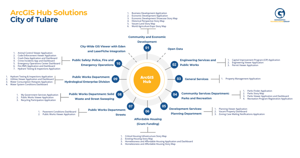
Key to the GIS Software Strategy proposed for the City is deploying Esri's ArcGIS Hub to provide access to the numerous Web Applications, Dashboards, Story Maps, and Open Data that were recommended in the plan. Within an ArcGIS Hub, GIS maps and applications are accessible from an easy-to-use web page along with any GIS data layers that the City wants to share. Among the more than 20 web apps recommended were tailored departmental GIS Viewers for Animal Control, Business Development, and Code Enforcement, to name a few. Several dynamic, location-aware Dashboards were recommended for city leaders to visualize Emergency Operations, Pavement Conditions, Water Systems, and more. Esri Story Map opportunities identified include Homelessness and Affordable Housing, the World Ag Expo, and a Parks Tour, which can be used to inform the public in an intuitive, interactive, map-centric context. It was further recommended that the ArcGIS Hub site be broken out into sub-hubs as well, allowing for each department, or group of departments, to have their own 'Hub' site while still being tied to the City's Hub as a whole.
As a part of Phase II, a detailed Digital Data Assessment was conducted examining the completeness, accuracy, and overall quality of the City's existing data layers. The City can use this information to improve any gaps and weaknesses found in the existing GIS data. A Return-on-Investment (ROI) analysis was also performed to communicate the value of GIS to the leadership and constituency. This analysis showed how completing the recommendations in the plan could improve efficiency, increase productivity, save time, and save money.
Phase III delivered a clear and concise multi-year action plan for implementing an optimum GIS solution. This step-by-step plan included detailed tasks with cost estimates to dramatically improve the City's success in the implementation of geospatial technology.
For the City of Tulare, GTG recommended a phased approach of implementation, with each year building on the foundation toward full ownership of GIS operations:
- Year 1: Adoption and Data Creation Phase
- Year 2: Deployment and Implementation Phase
- Year 3: Full Enterprise GIS Implementation Phase
Following this GIS Strategic Master Plan will allow the City's GIS team to effectively manage GIS as an asset and build a true enterprise system within three years.
Results
The information laid out in this GIS Strategic Master Plan details how the City of Tulare, CA can take steps toward building a foundation to expand its Geographic Information Systems to improve City operations. GIS can improve departmental efficiency by providing custom web applications for use by staff at all levels. These applications allow for direct interaction with departmental data that analyze GIS data in innovative and intuitive ways. They provide dashboards that monitor the status of City functions and engage the public through interactive websites informative Story Maps. Furthermore, with the integration of GIS with existing software and datasets, departments can improve processes that are already in place without moving to a completely new system. When the City adheres to the proposed recommendations set forth in this plan, follows best business practices, and ensures the transfer of GIS knowledge, it will set itself up for a successful Geographic Information System for many years to come.
—————–
To learn more about GIS strategic planning, visit GISPlan.com. You can also reach a GIS Strategic Planning Specialist at 888.755.0422 or via email to moreinfo@geotg.com.


