

Overview
The City of Concord is northeast and just inland from the San Francisco Bay area in California. Downtown Concord has evolved into the cultural center of the city with a thriving plaza and high-density apartment and condominium projects. As the 8th largest city in the San Francisco Bay area with a population of over 122,000, the City of Concord is focused on consistently improving all public services for their citizens.
One way the City is achieving its goals is actively improving GIS within targeted departments. Geographic Technologies Group (GTG) provided the GreenCityGIS suite for the City of Concord Parks and Recreation Department and created custom GIS Viewers and a Capital Improvement Project (CIP) application for the City. In March 2020, their Public Safety team reached out to GTG for support with their preparations for transitioning to Next Generation 911. They knew of GTG’s expertise and extensive experience with GIS data preparation, and GTG put together a proposal that met the needs and available budget of the City.
The Project
The City of Concord needed to have their GIS Data enhanced and migrated to the National Emergency Number Association (NENA) data standard in the preparation for moving to Next Generation 911. GTG proposed a plan that partnered with the City’s GIS team to work together to enhance and migrate the City’s Street Centerline and Address Point data layers to the NENA data model.
 NENA has developed a number of standards to support Next Generation 911 (NG911) and to link these standards to international standards related to emergency call handling, processing, and management. One of the standards defines the GIS data information, requirements, formats, and standards to support NG911. The importance of the data standard is to support both validations of the location information against the local 911 Authorities’ GIS data as well as to route the 911 call to the appropriate responding Public Safety Answer Point (PSAP).
To meet the requirements of the transition, GTG performed the following steps:
- Data Evaluation – GTG’s team ran the current Address Point Dataset through the ArcGIS Data Reviewer and gathered additional source data for address data comparison. This helped identify inconsistencies and data issues with street centerlines, parcels, county addresses, MSAG, datasets, invalid geometry, non-linear segments, and more. GTG also held a technical discussion with Concord staff and related stakeholders within the City to determine the best method to address errors between the GIS datasets, Addresses, and MSAG records.
- Address Data Report – GTG performed an Attribution Data Assessment and provided a detailed report along with a GIS data export containing identified potential issues.
- Data Migration – GTG worked with City of Concord staff to determine which Legacy Attribute fields they wished to keep and then migrated Address Point and Street Centerline data to the NENA Data Model.
- Data Editing and Improvements – GTG’s team performed a full edit of Street Centerlines within the Cities of Concord and Clayton. Tasks included correcting issues flagged by the ArcGIS Data Reviewer (Step 1), correcting line direction errors, removing unneeded breaks/segments in the centerlines, correcting/populating address ranges, assigning appropriate One-way codes, and much more.
- Create/Update Metadata – Metadata for Address Points was created and updated according to the standards set forth in the Geospatial Metadata Standards and Guidelines published by the Federal Geographic Data Committee (unless otherwise noted by City staff).
The Screenshot below shows examples of anomalies within the City’s Centerline Network.
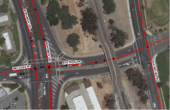
The example above shows an undivided highway along Systron Drive, incorrect street suffix abbreviation along Monument Boulevard (“BL” instead of “BLVD”), missing turn impedances at the intersection, and extra centerline segments along Systron Drive.
With all five steps of the project complete, the City of Concord now has in hand a NENA compliant Address Point layer and Street Centerline layer that is fully-routable. These updates will improve the Dispatch department’s ability to route public safety services more quickly and accurately. The City is now well-positioned to begin moving to Next Generation 911. Greg Beard, GIS Manager for the City of Concord, explains, “Our address point and street centerline data is much more accurate now. With potential issues highlighted, I’m able to work with the County and provide them with updated data when they were the verification source. It’s wonderful to have data we can rely on and continue to improve moving forward.”
Conclusion
The accuracy of GIS data impacts the quality of life, the ability to save lives, public confidence, and the ability to deliver services. One of the most critical uses for addressing is 911 and emergency service calls. This example highlights the importance of addressing for 911. At the dispatch center, a call is received. Data from the phone company (ALI data) is compared to either an MSAG for E-911 (Enhanced 911) or address points for NG9-1-1 (Next Generation 911). This validated data is then passed to the mapping application to be mapped. However, if the address from the E-911 does not match a valid address in the GIS file then the call will not be mapped or mapped in the wrong location.
Errors, inconsistencies, or ambiguities in the MSAG or address points will lead to incomplete addresses. Errors of omission and inclusion, non-standardized address naming conventions, and duplicate records can often lead to spatial inaccuracy, misrepresentation, or the inability to map an address. If calls for service or subsequently incident data (crimes, fires) are not accurately matched, staff must invest additional time and resources attempting to determine the location of the incidents manually, which can be a time-consuming process. This delay in time can cost the lives and/or property of the citizens.
Correcting Address Points and Street Centerline data is the City of Concord’s first step toward providing a fully reliable resource for 911 dispatch, emergency service routing, and other departmental needs. The City and GTG are currently discussing opportunities for enhancing Enterprise GIS services as well as integration services to better support the City’s Police Department, which will further improve the safety and livability of the City of Concord. The City and GTG have developed a great partnership over the past several years and are excited about what the future of GIS holds for City operations.
—–
To learn more about GIS data services, visit www.geotg.com. For details about GTG’s offerings for Public Safety, visit www.SafeCityGIS.com. You can also reach our expert team by calling 888-757-4222.


