
The City of Simi Valley Emergency Operations: Response to Quakes
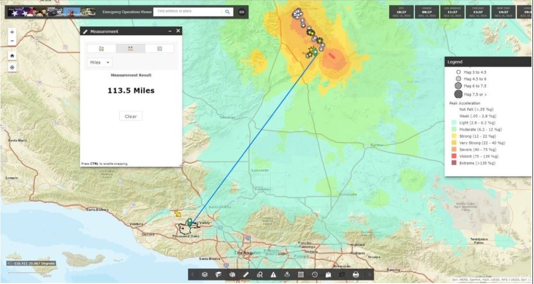
On July 5, 2019, a 7.1-magnitude temblor hit the Mojave Desert just outside of Ridgecrest, California, leaving a serious mark as one of the strongest earthquakes to hit Southern California in decades. The City of Simi Valley is in southern California half way between Santa Barbara and Los Angeles and just 113 miles south of the recent Mojave Desert quakes. Sitting near two fault lines – one of which is the major San Andreas Fault – Simi Valley is especially vulnerable. Fortunately for Simi Valley residents, the recent quakes caused minor trembles, but no serious damage, and there was no need to deploy Emergency Operation Center (EOC) services.
In May 2018, their Emergency Operations Center (EOC) reached out to Geographic Technologies Group (GTG) for a comprehensive GIS suite to interpret data used before, during and after any disaster event. They needed to visualize incident locations and details in a map-based representation to increase planning and response accuracy and efficiencies. This system was to be utilized to its full extent as a foundation for decision-making and strategic planning regarding the development and management of the daily operations of the City’s EOC.
When the July 2019 quakes occurred, the EOC was prepared with their Emergency Operations Viewer. They uploaded quake data into the program to visualize the location and magnitude of the quake and how it would affect their residents. Randy White, the Emergency Services Manager from the City of Simi Valley team says, “The quake was felt here in Simi Valley, but it was not damaging. We did not activate the EOC. However, we did use our SafeCityGIS program. We implemented the EOC Viewer to display the various quake data.”
The EOC GIS Viewer displays incident reports and data on an interactive map. It also contains numerous widgets for quick, dynamic analysis. It is used by emergency management personnel to understand the impact of an incident on public infrastructure and human populations. It marks relevant events on the map and includes an overview with details and status when selected. In the event of an incident or natural disaster, Operations Response is used to communicate the status of emergency facilities and response teams directly to the EOC directors. This allows EOC teams to plan their response actions efficiently and with the greatest impact in mind.
SafeCityGIS is an innovative enterprise and sustainable GIS management and analysis system and is changing and shaping the way that Emergency Operation Centers function, operate, and think about data. The system utilizes Esri’s foundation of new software products and provides a knowledge-based solution that delivers state-of-the-art geographic software, analysis, and visualization for situational awareness in real time. It is an irreplaceable turnkey solution that offers a host of benefits to the City of Simi Valley EOC, decision makers, field collection personnel, citizens and more.
“SafeCityGIS is an information portal that brings dozens of data sources into one geographic based environment. This allows EOC staff to rapidly consume and interpret data, and to develop situational awareness in support of the decision-making process.” explains White.
For more information about SafeCityGIS and the entire suite of public safety software solutions, visit SafeCityGIS.com


