

Tourism New Brunswick summarizes the City of Saint John, Canada, as “Urban Delights on the Magnificent Bay of Fundy.” As Canada’s oldest incorporated city, Saint John is a vibrant tourist destination, home to maritime history and charming port architecture. Renowned for its cultural diversity and thriving arts community, Saint John is also known for its profound use of innovative technology, having received the “Top 7 Intelligent Communities Award” in 2012 and recognition by URISA in 2014 for “Exemplary Systems in Government.”
In September 2015, the staff at the City of Saint John requested support for the creation and implementation of GIS software for Public Safety. They were looking for a way to map their information from their Computer-Aided Dispatch (CAD) Record-Management System (RMS). This system records calls to dispatch along with the history of calls based on the address of origination. While CAD handles live calls, RMS provides the history of incident data, warrants, accidents, arrests, and other important occurrences.
Geographic Technologies Group (GTG) proposed a solution that utilized the full SafeCityGIS suite – a cluster of software based on the Esri ArcGIS server environment. These software solutions include tools for dispatch, mobile response, crime analysis, public awareness, and data integration. The City of Saint John was excited to begin implementation.
 To provide the city with a CAD mapping interface, GTG implemented SafeCity Dispatch. This provides E-911 dispatchers with an interactive map that displays the location of all calls. The application connects directly to CAD data and provides a user-friendly interface for quick set-up. The SafeCityGIS Dispatch application displays mission-critical data including calls for service, Automatic Vehicle Location (AVL), GIS Data, and historical calls from the RMS.
AVL was an additional service provided in conjunction with the Dispatch application. AVL provides the real-time tracking of GPS-enabled devices and vehicles to view and record the movements of public safety units. Each unit is assigned a unique icon, and the AVL view can be filtered to show Police, Fire, EMS, Sheriff, K-9, Marine, Special Patrol, Detectives, Command Staff units, and more. Historical playback is also available to review response efforts and can be selected by unit, date, and date/time
A SafeCityGIS Public Safety Analysis application was installed for advanced crime analytics. This interface enables automated mapping and in-depth analysis of incident and call information based on location. It is designed for cities and counties of all sizes and complexities and is set up with dynamic query and browse capabilities to streamline crime and incident reporting. Saint John Public Safety departments integrated available GIS datasets to enhance visualization and perform spatial analysis of current data by attribute.
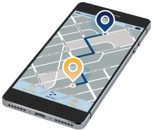
Mobile technology is vitally important to the response efforts of public safety teams. The SafeCityGIS Mobile application is the latest breakthrough as a software solution that allows all users to access GIS and dispatch information from remote locations. The mobile interface includes important data on active incidents, AVL units, and other user events as defined by public safety departments. Navigation within the app is driven via touchscreen or mouse, depending on the device.
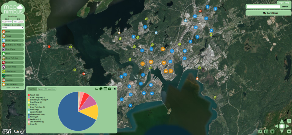
The final solution ensured the citizens of Saint John are kept up to date with incidents and crimes in their areas. SafeCityGIS MapNimbus is a web portal that’s easy to use and provides instant resident access to important and comprehensive public safety information. The application can be configured to display crimes, accidents, arrests, warrants, citations, and other data on an interactive map. It also offers the ability for residents to sign up for notification when incidents occur within any of their pre-defined areas of interest.
During the setup of GIS applications, the integration of key databases was of utmost importance. The City of Saint John’s public safety team needed to build database layers from their Versaterm and Niche systems. This is made possible with a data integrating software, such as GeoAdaptor provided by GTG. The GTG team also confirmed the full utilization of software by providing training sessions and documents to key users on the public safety teams. An annual maintenance subscription ensures the City of Saint John’s SafeCityGIS suite will be monitored, maintained, and upgraded as the software matures.
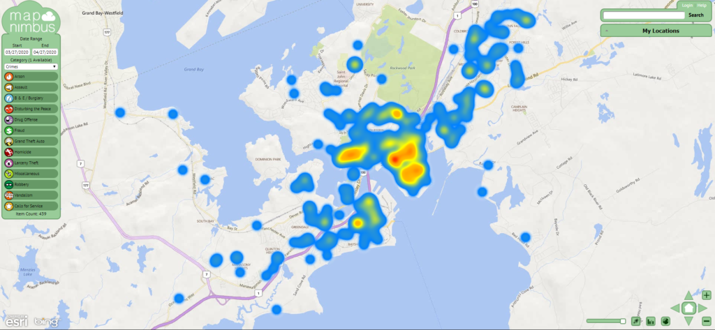
With the installation and implementation of Dispatch and Mobile tools for public safety, the City of Saint John will experience reduced response times to incidents and emergencies. Addressing and routing is more accurate, and the Crime Analysis application allows for the identification of patterns and trends to assist with allocating resources and officers throughout the city based on RMS mapped data. Government transparency is increased with MapNimbus, which leads to heightened engagement with residents.
The City of Saint John has a robust onsite GIS group to manage the new systems. The City is set up for success with the assistance and ongoing support of GTG for years to come. We have no doubt that this city on the Bay of Fundy will continue to thrive and innovate with its strong foundation of advanced GIS tools and technology.
——-
To learn more about the full suite of Public Safety solutions offered by GTG, visit SafeCityGIS.com, call 888-757-4222, or email James Kelt at jkelt@geotg.com.


