
Future Advancement: 3D Modeling and Open Data Portal at the City of Roswell
Introduction
The creation of a Smart City starts with a drive for innovation, and the transition doesn’t happen overnight. The implementation of GIS Strategic plans occurs slowly to allow for the creation of supporting programs and restructuring of government teams to facilitate the efforts. With a vision for the future, the City of Roswell, Georgia began their journey by utilizing the services of Geographic Technologies Group (GTG) in the development of a comprehensive GIS Strategic Plan.
Background
In 2015, the City of Roswell contracted GTG to perform a Strategic Assessment of the City’s GIS. The assessment identified nearly 50 metrics by which to measure Roswell’s existing GIS. Compared to successful GIS programs at other cities of similar size, Roswell’s GIS had numerous deficiencies. Several areas the Strategic Assessment identified for improvement are as follows:
- Roswell’s GIS was several years behind current technology and workflows.
- Several departments’ data was siloed and not shared among other departments that would benefit from access.
- City staff had a lack of awareness and understanding of GIS capabilities.
- Roswell had no mobile or online GIS presence.
- The City’s GIS website was functionally obsolete.
- There were no defined workflows.
- No integrations were in place with other enterprise systems.
Presented with the results, Roswell’s decision-makers and elected officials were motivated to quickly and aggressively modernize the City’s GIS to be a regional leader and to align with Smart City principles. Roswell once again collaborated with GTG to create and implement a 3-year GIS Strategic Implementation Plan to provide a road map for achieving realistic and prioritized objectives to support the modern, Smart City goals. Numerous critical checkpoints were achieved to set the City up for success during those three years, and now the City has partnered with GTG to develop and deploy two cutting-edge GIS initiatives: City of Roswell, Georgia Geospatial and Open Data Hub, and the City of Roswell 3D Historic District.
Over the past three years, Roswell has made a considerable investment in modernizing and leveraging the City’s GIS to make Roswell more effective as an organization, and more transparent as a local government. During this period, Roswell’s GIS has gone from relative obscurity, to being featured in nationwide industry publications. The City’s rapid adoption and deployment of enterprise GIS solutions has dramatically elevated the visibility and usability of GIS for both staff and citizens and illustrates Roswell’s commitment to data-driven decision-making processes that best serve the residents and visitors.
– Gary Palmer, City Administrator
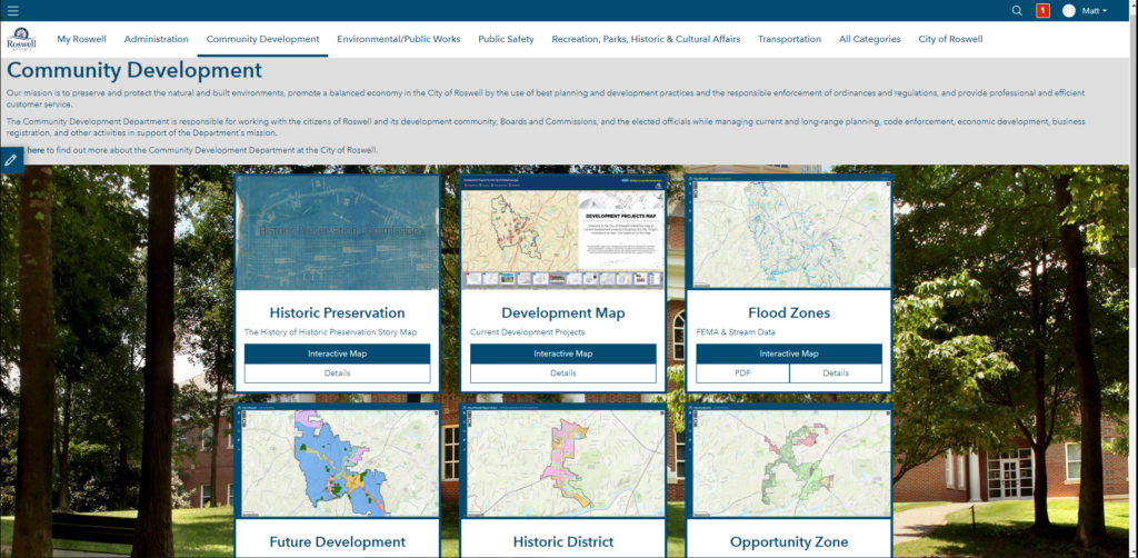
City of Roswell, Georgia Geospatial and Open Data Hub
Fast forward to 2020, and the City of Roswell has transitioned from limited GIS usage and exposure to a regional leader in GIS data and applications. This quick ascension resulted in a wealth of applications and data that needed a central environment for public consumption. Enter ArcGIS Hub, an easily configurable community engagement environment that has revolutionized how organizations connect their public and vendors with data, documents, and initiatives.
While ArcGIS Hub sites can be deployed with a variety of goals in mind, the City of Roswell’s vision led to the creation and deployment of The City of Roswell, Georgia Geospatial and Open Data Hub. This common operating picture houses all publicly available GIS applications — categorized by department — and allows site visitors to download GIS data deemed appropriate for public consumption. It also acts as a One-Stop-Shop for all GIS-related data, applications, and technology for the City of Roswell.
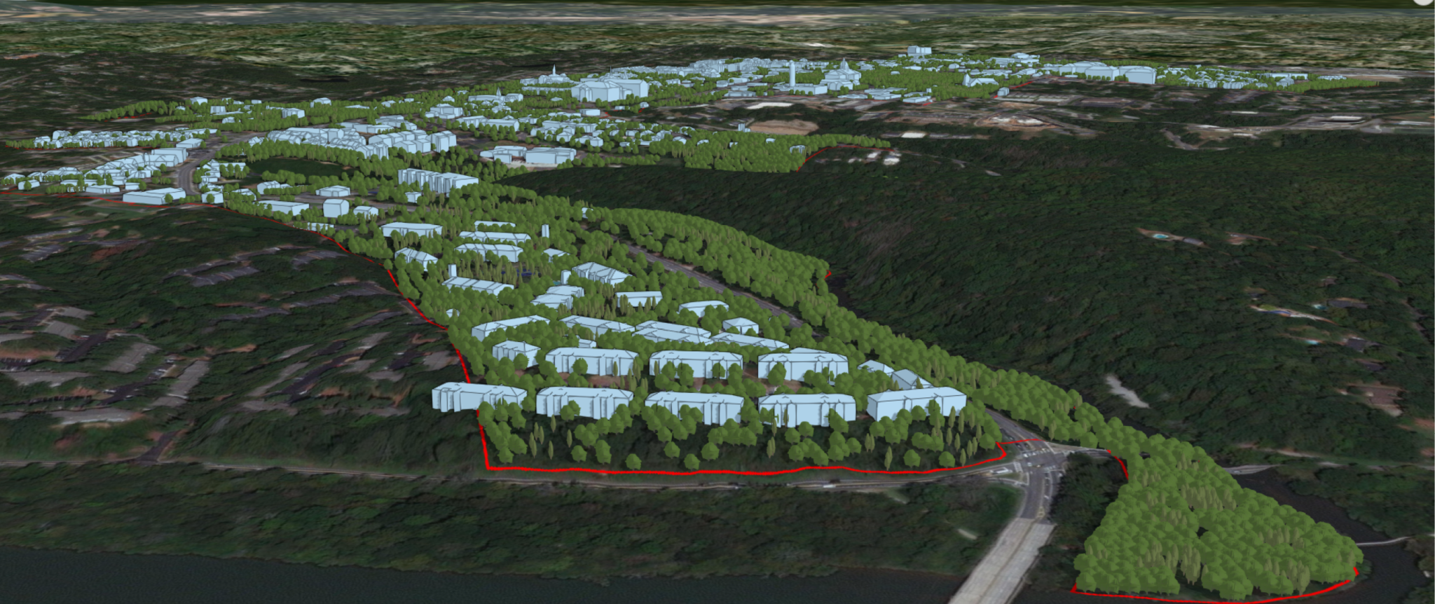
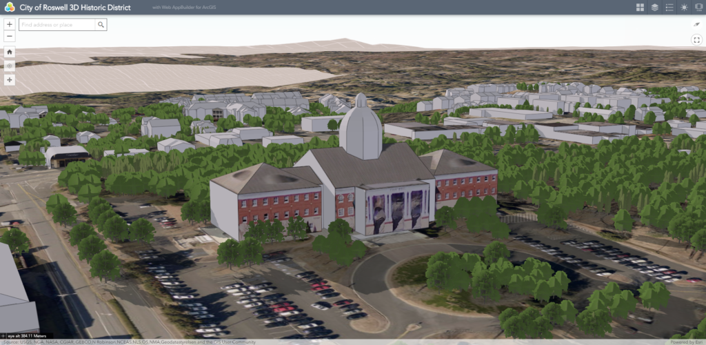
City of Roswell, Georgia 3D Historic District
After building a solid GIS foundation during the early stages of the three-year journey, the City of Roswell embarked on a groundbreaking new chapter to develop an interactive 3D Historic District. By early 2020, Phase I was complete and visitors of the application can leverage the virtual environment to tour the City of Roswell’s Historic District. Internally, staff have the capability to evaluate potential developments in the virtual realm during planning phases. Additionally, this environment allows supplemental 2D data to be brought in and viewed alongside the 3D features. Potential future phases could include an expansion of the texturing throughout the Historic District, the inclusion of additional 3D features (e.g. utilities), and/or expansion of the 3D landscape beyond the borders of their Historic District.
Conclusion
With the implementation of their 3-year GIS Strategic Plan along with the deployment of the ArcGIS Hub and the City of Roswell, Georgia 3D Historic District, the City is well on its way to becoming a Smart City. City staff have impressively come together to implement innovative solutions across departments. They’ve successfully streamlined sharing of information and more efficient communication between teams. With GIS, The City of Roswell will move forward with confidence that they are best serving their citizens and their community.


