

In June of 2019, the City of Rancho Cucamonga, California selected Geographic Technologies Group (GTG) to assist with the creation of a GIS-based Fiber-optic Management solution. City officials recognized the value of creating a fiber-optic infrastructure, as it not only supports economic development, but also aids in long-term sustainability and Rancho Cucamonga’s future planning initiatives. The City’s goal is to create a fully connected community, from city operations to education, public safety, and healthcare. Rancho Cucamonga Municipal Utility partnered with Inyo Networks to create Rancho Fiber and deliver gigabit speed internet for the City’s Fiber Master Plan.
To fulfill the City’s need for tracking all fiber-optic related data (cables and infrastructure points), GTG delivered a full Fiber Management System (FMS), also known as VisionFMS. VisionFMS is a lightweight, easy-to-use, and convenient software for organizations new to broadband to create fiber networks. The application allows Rancho Fiber to plan, design, budget, and manage their OSP assets … all within an Esri-based platform. The result of implementing VisionFMS is a municipality can then aggregate all utility data and GIS managed inside of any Esri Enterprise Geodatabase.
Key Features of VisionFMS:
- Built as a plug-in for ArcGIS Desktop — Integration with Esri’s flagship product allows teams to leverage all available Esri tools.
- Smart Wizard Driven GUI – Specifically built for municipalities and utilities deploying fiber broadband networks, the wizard flow acts as a simple “guide” for fiber asset data entry so that no attribution that is crucial to future identification and reporting will be skipped or omitted.
- OTDR Measurement Tool – Provides the ability to pinpoint where a fiber cut has occurred on a cable/strand by inputting OTDR data straight into VisionFMS.
- Project and Materials Costing – Allows officials to estimate costs by project or spatial selection to build ROIs and simple financial models for fiber-optic network expansion and budgeting.
- Splicing Tool – Everybody has a splicing tool…but Vision FMS’s offering is simple to use and view, and provides different splicing methods, wave reporting, and easy share/print functionality.
- B/OSS Integration – Grants the ability to push address points and location records, which start in the GIS group, to billing and operational database systems. This maintains location data integrity and accuracy throughout an eco-system and avoids conversion and repetitive manual data entry.
- Versioning – Vision FMS leverages Esri’s out-of-the-box ability to have multiple editors creating and updating the plant database at one time. This allows a separate “version” for each editor to then follow QA guidelines for teams to update and approve designs efficiently and quickly.
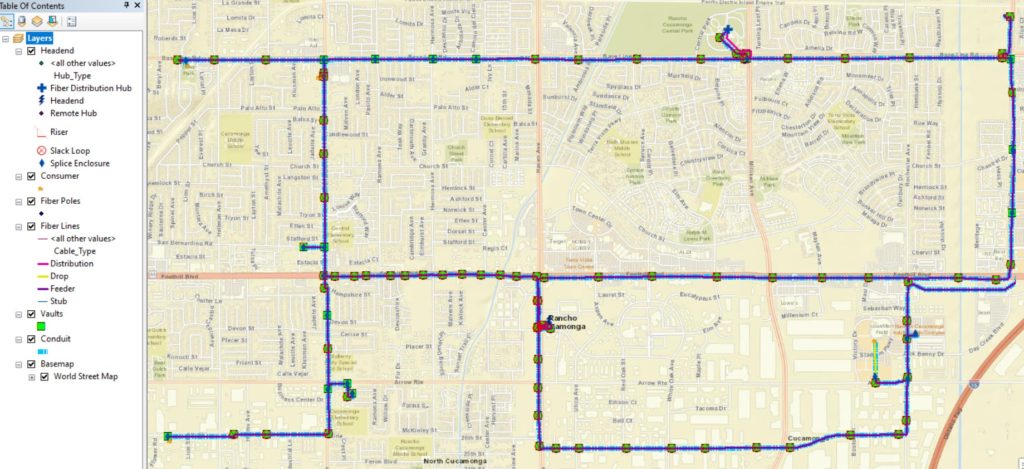
While the City of Rancho Cucamonga is still building its backbone fiber network, their team anticipates a strong return from their investment in fiber-optics infrastructure and VisionFMS. The City’s current Fiber Optic Master Plan outlines an existing network infrastructure of 96 strands spanning 25 miles and serving over 14 city facilities. Phase 1 of their six-year investment plan details connecting City and traffic conduit gaps and expanding the conduit infrastructure to key areas of Rancho Cucamonga. With VisionFMS, they are setting their team up for long-term success.
For more information about VisionFMS and the full suite of products and services available with Geographic Technologies Group’s FiberCityGIS program, please visit FiberCityGIS.com. You can also reach a member of the GTG team at 888.757.4222.


