

Implementing State of the Art Technology on a Budget
Case Study: City of Fort Pierce, Florida
A gem on the Treasure Coast of Florida, the City of Fort Pierce is known as a quaint fishing village. With a population of just over 41,000, this diverse city still surprisingly offers the cultural excitement of its larger counterparts. It is home to the Highwaymen Heritage Trail, the pristine Indian River Lagoon, and the National UDT Navy SEAL museum, among many other tourist attractions.
The City of Fort Pierce has a strong mission: “To provide community leadership, quality public service, and a safe environment for all citizens, by an empowered team of employees motivated by pride in themselves and their work.” To support its mission and provide excellent service to the community, city officials employed the guidance of Geographic Technologies Group (GTG) to fully utilize GIS technology. With a desire to grow the GIS, the City of Fort Pierce, Florida contracted GTG to create a Strategic Implementation Plan in February of 2020. Their comprehensive and multi-year GIS Implementation Plan involved a GIS Needs Assessment, Alternative System Design, and a Phased GIS Implementation Plan to create a roadmap for success.
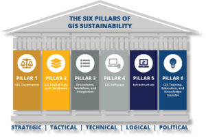 GTG’s plan creation methodology uses the Six Pillars of GIS Sustainability to guide the roadmap, which are 1) GIS Governance; 2) Data and Databases; 3) Procedures, Workflow, and Integration; 4) GIS Software; 5) Infrastructure; and 6) Training, Education, and Knowledge Transfer. It also addresses strategic planning organizational needs, system design alternatives, and phased strategic implementation.
Work on the City of Fort Pierce’s project began with telephone and onsite interviews with IT and GIS department staff. Key staff members from other departments were also interviewed to assess their experience with and knowledge of GIS. GTG asked questions of the team to evaluate the existing GIS and IT environment along with GIS software licensing. This information collection phase led to the creation of a GIS Needs Assessment report that identified high-priority GIS application needs for internal and external use. The assessment process effectively provided a benchmark of existing GIS conditions, an analysis of existing gaps, and the introduction of Key Performance Indicators (KPIs) by which to monitor and measure future growth and success.
Needs identified for the City of Fort Pierce included both enterprise-wide initiatives as well as departmental solutions. Of highest priority was the creation of a City-wide Geospatial HUB solution to include Web Apps, Dashboards, and Story Maps for each department. Building an ArcGIS Hub solution introduces new opportunities to an organization by leveraging the power of City resources, including community data and information, community knowledge, community relationships, and innovative and collaborative intelligence. ArcGIS Hub can reinvent the organization by leveraging community data and technology and embrace internal and external stakeholders. ArcGIS Hub is the future of data sharing and data communication and includes the following GIS applications from GTG and Esri:
- Web Apps – Web AppBuilder for ArcGIS is an intuitive application that allows the building of 2D and 3D web apps without writing a single line of code. It includes powerful tools to configure fully featured HTML apps, made to display and analyze data on any device. Developers can build custom widgets and themes to extend Web AppBuilder for ArcGIS.
- Dashboards – Today’s statistical dashboards help monitor important real-time information about the day-to-day operations of government. Custom statistical real-time, data-driven dashboards provide a comprehensive view of the data most important to the viewer.
- Story Maps – Story Maps display information for the public in a visually appealing way. It is an extraordinary tool that allows for the creation of inspiring geospatial stories by combining text, interactive maps, and other multimedia content. They make it easy to harness the power of maps and geography to tell a story.
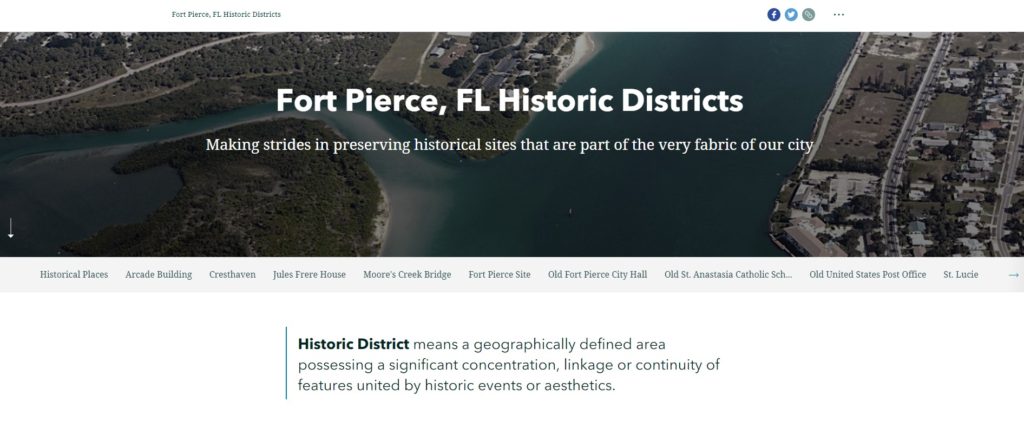
GTG assisted the City of Fort Pierce with the creation and implementation of a StoryMap featuring Historic Districts.
Departmental needs were addressed at the City of Fort Pierce to provide integrated utilization of GIS at the Enterprise level. GTG recommended the Building Department implement a Building Permit App and Dashboard, a Hurricane Preparedness Dashboard, and a Damage Assessment App. The Police Department recommendations included a Command Center Dashboard integrated with their RMS, a Hazard Mitigation and Preparedness App, a Crime Mapping App and Dashboard, a public-facing Story Map, and ArcGIS Insights for crime analysis. The Public Works Department received recommendations for implementing a Parks Amenities App, Street and Drainage Asset Management App and Dashboard, Solid Waste Routing and Scheduling App, and a Park Asset Inventory with GTG’s GreenCityGIS suite of services.
Detailed recommendations were also included for Code Enforcement, Animal Control, the City Marina, the Engineering Department, and Planning Department. Further enterprise recommendations included My Government Services App, crowdsourcing applications like Survey123, field data collection (Collector for ArcGIS and ArcGIS Quick Capture), and work order management with Workforce for ArcGIS. All recommendations were presented to the city in order of priority and efficiency for department teams.

With needs prioritized, GTG’s team delivered the strategic plan for GIS implementation. Detailed steps were included for all ten high-priority GIS projects, and included the purpose, outcome, and best practices. The next step was to present the final findings to key Fort Pierce stakeholders. Discussions took place to determine the needed budget and to set a step-by-step schedule for full implementation. GTG also included a plan for maintaining GIS applications, which created a sustainable strategy for the City of Fort Pierce.
The GIS Strategic Plan was critical to the success of the City’s GIS initiative. A structured and understandable plan of action saves time and money, as well as resources. The GIS strategic planning process helped the City of Fort Pierce understand their existing GIS conditions, identify needs, and build a long-term plan for healthy and sustainable growth.
With the GIS roadmap finalized, city officials immediately moved to begin the implementation of recommended applications and GIS solutions. Benefits of GIS implementation include a more informed and engaged public, more efficient communication between departments, and streamlined data sharing. With staged implementation, GIS is truly scalable and sustainable and able to fulfill all the needs of the City of Fort Pierce now and for years to come.
—–
To learn more about GIS roadmaps and strategic planning, visit GISPlan.com. You can also reach a GIS expert at 888.755.0422 or via email to moreinfo@geotg.com.


