

GTG and Esri Partner to Develop a Strategic GIS Work Plan and Governance Model for the City of Farmers Branch, TX
The City of Farmers Branch has a growing population of nearly 40,000 people and is in the Dallas–Fort Worth–Arlington Metropolitan Statistical Area (MSA). The City boasts their location as “an oasis of small-town life in the heart of big-city bustle.” Just minutes from downtown Dallas, Farmers Branch is quickly growing with families looking to put down roots in safer, quieter neighborhoods, with easy access to idyllic parks, great schools, and state-of-the-art recreation facilities.
Existing Conditions
To serve its growing community, The City of Farmers Branch built the foundation for an excellent, innovative, and sustainable hybrid GIS governance model. GIS governance refers to all of the processes and actions required to manage the planning, design, implementation, and on-going innovative use and maintenance of Geographic Information Systems (GIS) technology.
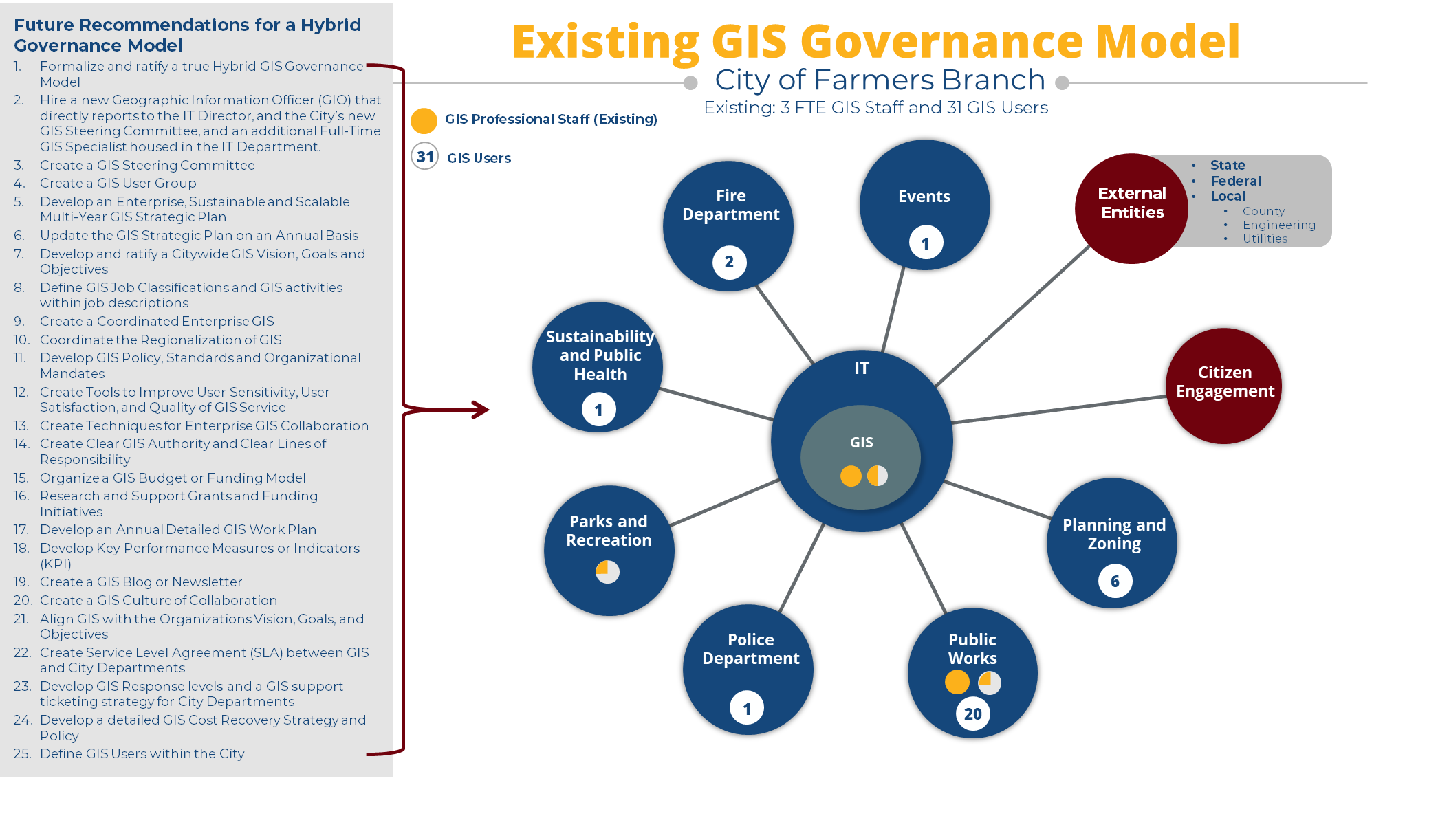
The conventional wisdom is that GIS should always be located in the IT department, as the IT department serves all departments equally. This model is typically supported by full-time GIS Subject Matter Experts (SME) in key departments throughout the City. The City of Farmers Branch has three full-time equivalent GIS staff throughout the City, including a GIS Administrator, a GIS Intern housed in the IT Department, and a GIS Technician and Senior Engineering Specialist in the Public Works Department. The remaining staff with GIS experience are in the Parks and Landscape Department and contribute to GIS management. Overall, the City has approximately 31 users of GIS software in 6 departments.
The City’s small GIS team in IT understandably centralizes GIS activity by working for each department to put-out-fires, make maps, and actually do the GIS work for each department, as well as maintain digital data layers. The GIS Administrator and intern tend not to be enablers, but GIS technicians for each department. The general observations about the City’s GIS Governance Model is that the “the city is built out on a total of 12 square miles with a population of 40,000 people, and GIS is a one-man shop with 400 staff to support.” Therefore, the City of Farmers Branch had some existing centralized, decentralized, and hybrid GIS governance characteristics.
Turning to the Experts
To add clarity to their situation and work towards taking calculated actions to grow their GIS in a healthy way, the City contacted Esri and Geographic Technologies Group (GTG) to assist with the development of a comprehensive GIS Strategic Work Plan.
Esri specialists and GTG CEO, David Holdstock, partnered with the City of Farmers Branch to create a business-oriented geospatial strategy that would help the City manage significant population change and growth. To effectively assist with the project, GTG and Esri needed to understand politics, personalities, lines of communications, and all management variables. Holdstock explains, “We knew the resulting strategy must focus on implementing solutions to address the consistently expressed needs of the six departments utilizing GIS technology, so we conducted onsite interviews of key stakeholders to gain a deeper understanding of current GIS use and structure.” It was determined that the solutions presented must enhance situational awareness and data-driven decision-making, advance the monitoring and tracking of resources and spending, improve communication to the public, and enable a City-wide understanding of GIS. All this had to be achieved in a way that was technically feasible and sustainable with an appropriate GIS governance model to enable appropriate and effective use of GIS technology.
Recommended Solutions and Strategy
The City of Farmers Branch was in a prime position to become smarter with geospatial technology. A phased and deliberate approach to meeting the challenges of using GIS throughout the organization provided opportunities for improved efficiency, increased productivity, time and money saved, and better decisions made. Other opportunities included improved data access, automated workflows, improved information processing, compliance with state and federal mandates, improved communication, better coordination and collaboration between all stakeholders, and data made available for regulators, developers, and the public. Improved GIS also means responding quicker to citizen requests, improving citizen access to government, increasing community safety, and effectively managing City assets and resources.
Each of the City of Farmers Branch departments emphasized the need for all of the improvements listed above but also the need for improved guidance, deployment of data standards, clarity of GIS roles and responsibilities, reduction of manual processes and associated wasted time, and opportunities for open data and data sharing with the public.
Based on these challenges and needs as well as conventional wisdom and best business practices in GIS, GTG recommended the necessary components required to implement a sustainable Hybrid GIS Governance model. Holdstock states, “Some of these components included the creation of a GIS Steering Committee, hiring a new Geographic Information Officer and full-time GIS Specialist for the IT department, and the development of GIS Policy, Standards, and Organizational Mandates, among many other recommendations best suited for their unique situation.”
GIS Governance
The evolution and maturity of GIS governance in local government over the past 30 years has seen a natural, albeit clumsy progression from a young decentralized GIS model to a centralized GIS model, to today’s modern and mature hybrid governance model with regional characteristics. Today’s hybrid model is characterized by a key GIS Manager or Geographic Information Officer (GIO) that is ultimately accountable for all geospatial activity within the organization, supported by the right number of key GIS staff to maintain critical data layers and, most importantly, enable all departments with desktop, web and mobile GIS solutions (Strategic GIS Planning and Management in Local Government, 2016).
GIS governance is a social and political process, and the aggregated experiences of local government organizations prove that achieving an operational GIS does not guarantee its use. Correct implementation of an appropriate governance model can give rise to positive and beneficial characteristics in an organization. Conversely, selecting and or implementing a poorly suited governance model that does not follow basic implementation principles can have negative consequences. The ultimate success of an enterprise-wide GIS will depend on the ability to govern and manage GIS in an evolving multi-departmental environment. It must include complex strategic, technical, tactical, logistical, and political issues that accompany GIS technology.
Many local governments utilize a Hybrid GIS Governance model: An approach that incorporates the benefits of each of the centralized and decentralized organizational models is a happy medium — the best of both worlds — and this was the model selected for implementation by the City of Farmers Branch.
Benefits
A Hybrid GIS Governance model for The City of Farmers Branch uses dual accountability along functional lines. When successfully implemented, the hybrid model benefits the organization in many ways:
- Shared costs
- Database management and maintenance
- Network and server resources
- Highly specialized GIS staff
- Improved efficiency
- Integrated multi-departmental solutions can be implemented
- Central data warehouse
- Team-based processes (critical functions are no longer one person deep)
- Improved data quality
- Departmental ownership of relevant datasets is maintained
- Automated validation routines
- Real-time distribution of data
- Improved end-user support
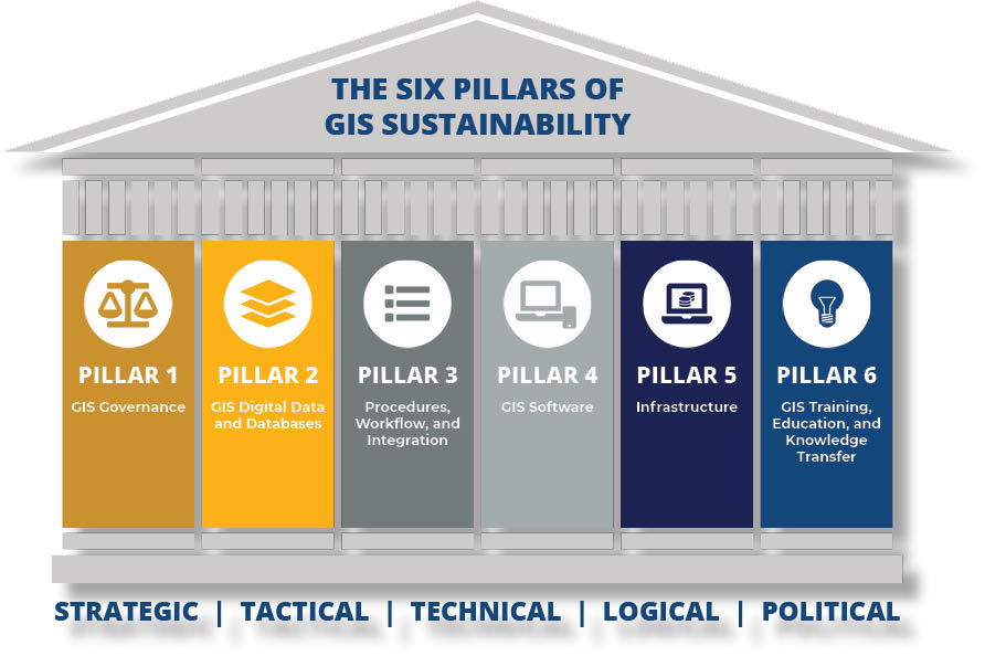
With the creation of a Hybrid GIS Governance model for their organization, and technology implemented to maintain data and support their GIS infrastructure, The City of Farmers Branch was well on its way to fulfilling a full set of GIS goals and objectives in alignment with GTG’s Six Pillars of GIS Sustainability:
- Governance – Implement an Optimum Hybrid GIS Governance Model
- Data & Databases – Design, Build, Update, Collect, and Maintain Reliable and Sustainable GIS Digital Data Layers
- Procedures, Workflow, and Integration – GIS integration, interoperability and efficient workflow throughout the organization
- GIS Software and Geospatial Technology – Make GIS Software and Geospatial technology to all stakeholders including City staff, residents, and all interested parties
- Infrastructure – Build and Maintain IT Infrastructure to support an Enterprise, Scalable and Sustainable GIS
- GIS Training, Education and Knowledge Transfer – Train, Educate, and Promote Knowledge Transfer for all City Staff
Conclusion
The City of Farmers Branch required a GIS Strategic Work Plan and retained Esri specialists and GTG to make it happen. Onsite collaboration for department interviews and presentations were utilized to identify primary GIS needs and to educate the team on best practices and practical solutions. While Esri specialists worked on implementing technological solutions, GTG was tasked with building a plan to best manage GIS/digital data and databases, as well as training and education for internal teams – the governance of the GIS. With the results from an onsite needs assessment in hand, GTG developed recommendations for what a new, enterprise-level, Hybrid GIS Governance Model would look like. With the combined knowledge and resources of Esri specialists for technology solutions and GTG for a governance model, The City of Farmers Branch created a comprehensive GIS Strategic Work Plan with a Hybrid Governance model that will serve their organization through years of aggressive growth.


