
SmartCityGIS: ArcGIS HUB and Departmental Business Applications for The City of Hobart, Indiana
The City of Hobart, Indiana is one of the county’s oldest communities. With a population of just over 29,000, Hobart provides a close-knit community on the banks of Lake George. Residents and visitors enjoy thriving retail opportunities, a lively downtown district, and great schools a mere 38 miles outside of Chicago, Illinois. Hobart quickly grew from a small town to a bustling city.
In early 2019, a small cadre of experienced and visionary staff with The City of Hobart Sanitary and Stormwater District (HSD) recognized the benefits of geospatial technology and location intelligence to transform the city. This team reached out to Geographic Technologies Group (GTG) to write and implement a GIS strategic plan. With GTG, and with the help of Nearmap’s aerial imagery, HSD developed a City-wide, multi-year, phased GIS roadmap, secured buy-in from all stakeholders, dedicated funding for this modernization project, and is successfully building an enterprise, sustainable, resilient, and scalable geographic information systems (GIS) solution.
A Comprehensive Strategic Plan
The City of Hobart’s geospatial initiative is envisioned to govern, coordinate, and implement a comprehensive city-wide GIS to serve a growing need for the delivery of geospatial data to internal and external customers and to enable integration with supported business systems. At the core of this was the need to align the GIS to support the overall vision and goals of the Mayor and City Council.
The GIS Strategic Planning process included eight steps broken down into three focused phases. The initial phase included an assessment of HSD and the City of Hobart’s current GIS. GTG interviewed key stakeholders, performed a strengths, weaknesses, opportunities, and threats (SWOT) analysis, identified gaps, and presented a report for benchmarking and key performance indicators (KPIs). This first phase concluded with a GIS Needs Assessment Findings report and presentation. Phase Two was focused on alternative system design. The alternative system design laid out recommendations and best practices for the organization as a whole as well as per department based on the needs identified in the first phase. Phase Three kicked off with a look at the GIS Return on Investment and concluded with the presentation of a formalized GIS Strategic Roadmap for stakeholders. As with all plans drafted by GTG, each phase and accompanying deliverables adhered to the Six Pillars of GIS Success:
- GIS Governance (Support and Operations)
- GIS Digital Data and Databases (Accurate and Reliable)
- Procedures, Workflows, and Integration (Interoperability)
- GIS Software (Total Ecosystem)
- Infrastructure (Architectural Design)
- GIS Training, Education, and Knowledge Transfer (Sustainability)
With a strategic implementation plan in place, HSD and the City of Hobart staff worked with GTG’s team to bring items in the plan to fruition. ArcGIS Online Organization was deployed along with Microsoft Azure VM as a virtual web server for hosting the custom GIS applications and other media. They also customized and deployed internal and external ArcGIS Hubs, an Open Data Portal (public-facing), and a variety of departmental viewers, dashboards, and story maps.
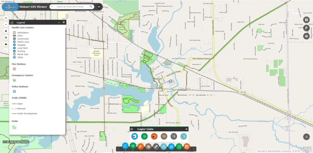
An Elevated GIS Viewer
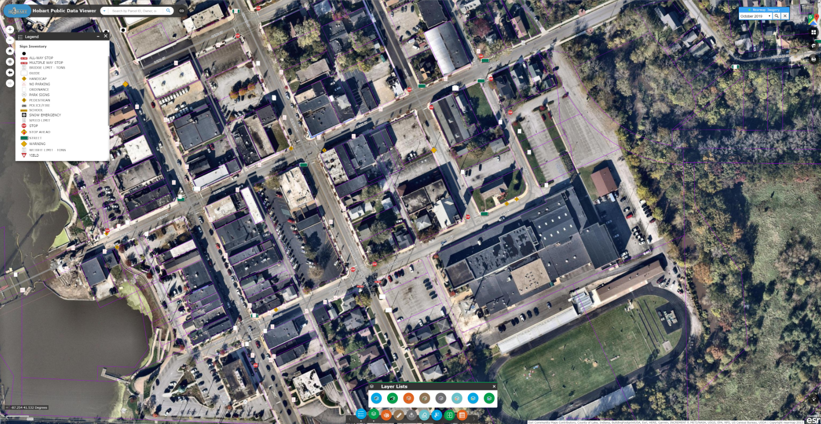
Before working with GTG, HSD was maintaining a GIS viewer web app from a previously contracted vendor. The technology was not user friendly, and thus underutilized. Leaders recognized the need for an interface that would sufficiently serve the District as well as other city departments while being intuitive, adaptable, and easy to navigate.
GTG provided an alternative solution to the outdated tech with a GIS Viewer built on the Esri Web AppBuilder browser. This viewer was equipped with user-friendly controls and was customized to address all the needs of the District team. Customizations included integrations with key software databases from Nearmap and RedZone.
Nearmap is an agency that collects high-resolution aerial imagery for the District three times each year. Since 2019, the company has released a number of innovations designed to help government agencies garner greater insights from aerial imagery and the use of location intelligence. Nearmap’s 3D imagery provides local governments the ability to quickly export custom areas for use in platforms such as Esri, Bentley Systems, and Autodesk. Nearmap AI enables governments to instantly identify attributes about properties required for the appraisal process and Nearmap AI Packs enable users to determine the type of access made visible in Map Browser for items such as impervious surfaces, vegetation, and solar panels at a citywide scale.
Nearmap’s library of aerial imagery provides some of the most accurate imagery available with updates occurring up to three times a year throughout more than 430 markets in North America, including 700 urban and regional areas accounting for more than 70 percent of the United States population.
“Our range of high-resolution aerial content — from Vertical to Oblique, 3D and AI — integrates easily with GTG’s applications and acts as a valuable component to the strategic planning services offered by GTG,” said Karl Terrey, Director, Global Alliances at Nearmap. “Our imagery is refreshed multiple times per year and when combined with GTG’s technology allows cities, towns, counties, and state governments to make decisions based on conditions in their communities in near-real-time, at a fraction of the cost.”
With the city of Hobart’s investment in this resource, it was imperative to make this imagery available through the GIS Viewer. With the help of Nearmap’s technology, GTG was able to create a custom widget that allowed staff to expand a window within the Viewer to list all accessible imagery by the date of the flight. Historical Nearmap data dates back to 2015.
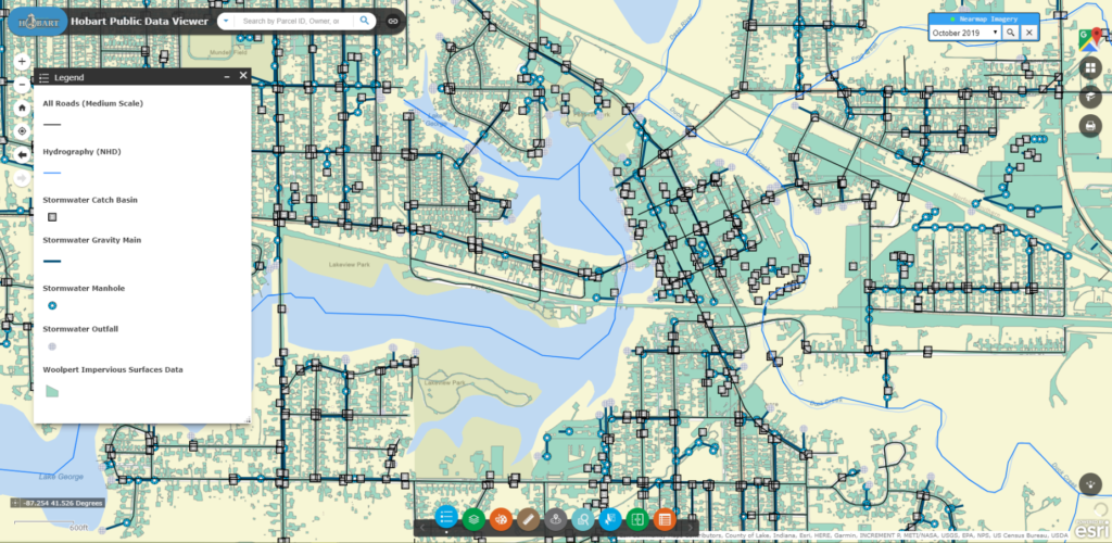
The District’s GIS Viewer also shows parcel data linked from the County Assessor’s website. The County Assessor maintains official records regarding all city parcels, including historical ownership information, engineering sketches, photos, and more. This is a great source of information for the Planning and Development Departments, and GTG’s integration made it possible to easily view all data from within the GIS Viewer. The user must simply locate a parcel on the map, click on it, and they will then be taken directly to the associated County Assessor web page.
Education and Data Sharing with ArcGIS Hub
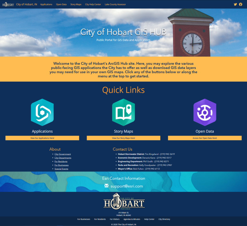
Another key piece of the City of Hobart’s GIS strategy was the creation of two ArcGIS Hubs — one for internal teams and one for public engagement and awareness. This internal Hub is an informational web page that is fully customizable. It includes links to Nearmap’s high definition images and other GIS applications, as well as any additional departmental information the city would like to include to create a centralized data gateway – a GIS Hub. The main page serves city-wide initiatives with the primary GIS Viewer, and then there are sub-pages for each department, including the Sanitary and Stormwater District, Planning and Development, Police, Fire, Parks and Recreation, Economic Development, and any other departments that utilize GIS.
The Hubs can be added to as the City’s GIS grows. The intent is that GTG will continue to develop solutions and applications and then will place them on each department-specific page as internal tools for each team. When someone needs to view their department’s applications, they simply go to their sub-page and access all the direct links to available data and interfaces. The Hub also increases transparency and communication between teams, as each department can view other departmental sub-pages and the linked applications.
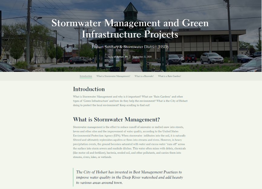
 The City of Hobart also created an external site and utilizes the Hub as an open data portal. When you visit the website, you can download any GIS files from Nearmap’s archives that the city has identified as “open data.” For example, a citizen may choose to retrieve city park shapefiles for a school project or report. Community members are also able to view a variety of GIS applications, such as a GIS Viewer (that omits any confidential information) and Story Maps to increase GIS awareness and an understanding of City initiatives. For example, the HSD has invested over $1.25 million into green infrastructure around the city. The “Stormwater Management and Green Infrastructure Projects” Story Map helps the HSD educate citizens of Hobart about some of the efforts that have gone into reducing runoff pollution and improving local water quality.
A Thriving Smart City
With all these tools in place and the quickly growing GIS infrastructure, the City of Hobart is well on its way to creating a thriving Smart City.
The City of Hobart is building the foundation for a Geo Smart City that embraces the core principles of:
- Improved awareness of location intelligence throughout the organization
- Development of departmental-specific business applications
- A ratified GIS governance and management model that will guide the City’s geospatial growth
- Expanded access and effective use of accurate, reliable, and well-maintained digital data
- A phased integration and focus on interoperability between all systems – a system of systems
- Deployment of a modern cloud-based framework for software and IT Infrastructure
- Promotion of economic, environmental, and social development
In the year since Hobart integrated GTG’s GIS Strategic Plan, the city of Hobart saw greater citizen engagement using their GIS Viewer that allows them to find information for themselves. The GIS Viewer also has made sharing information more efficient and organized that is user-friendly and is a much more accessible tool to Hobart’s citizens. City officials themselves have also invested efforts into the accuracy of its GIS assets, reconciling issues in GIS data with other sources.
The multi-year GIS Strategic Plan provided guidance for continued GIS training and opportunities for City employees. The City of Hobart is following the recommendations in its GIS roadmap to ensure sustainable GIS governance and has identified 16 areas that showcase GIS return on investment (ROI). The City’s current project with GTG is modeling City buildings in 3D, a tool that aids future planning with visual renditions that highlight patterns, trends, and non-obvious spatial relationships.
As a result of the success of this campaign, the city of Hobart earned the IGIC Excellence in GIS Award. This award recognizes organizations in six different categories for their use of geospatial technology to improve our world. Read more about this award here.
For more information about Smart Cities and GIS technology, visit SmartCityGIS.com or call our team at 888.757.4222.


