

One of California’s original counties, Yolo County was founded in 1850 and developed along the Sacramento River in northern California. The County provides comprehensive services to its over 220,000 residents in four municipalities and unincorporated areas covering 1,021 square miles of mostly agricultural land. The County is home to world-renowned University of California-Davis campus and the busy Port of West Sacramento.
The Yolo Emergency Communications Agency (YECA) is a Joint Powers Authority formed in 1988 as a consolidated 9-1-1 Public Safety Answering Point (PSAP) to provide dispatch services for police, fire, and animal control for four law enforcement agencies and 18 fire agencies in Yolo County and parts of Colusa and Sutter Counties.
Since YECA handles over 300,000 calls per year and dispatches an average of 165,000 law calls, 28,000 fire calls, and about 10,000 animal control and support services calls annually, it is imperative that the location information used in their dispatch system be as up-to-date as possible. Yolo County government and the cities of Woodland, Davis, and West Sacramento maintain address point, street centerline, and fire hydrant data for their respective jurisdictions and supply this information to YECA regularly. The issue of how to get the data additions and revisions into the Computer-Aided Dispatch (CAD) system and ultimately into the hands of the dispatchers, led YECA to outsource GIS database update and management tasks.
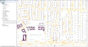
Street centerlines and address points are shown for a neighborhood in Davis, CA.
Starting in January 2018, YECA contracted with Geographic Technologies Group, Inc. (GTG) for technical consulting services to perform edits to the agency’s critical GIS datasets from data received from the county and cities. YECA relies on GTG to keep the street centerline network, address points, fire hydrant points, and public safety response area polygon layers updated with the latest changes in the streets and addresses within the YECA’s service area. The four public safety response areas layers aid in dispatching responders according to Fire Response Areas, Police Response Areas, Animal Response Areas, and Support Response Areas.
The process involves YECA transferring the county/city data to GTG each month, along with the current YECA database and instructions for any adjustments needed on the Response Areas boundaries. GTG GIS technicians then evaluate the county/city data to identify features that do not match the YECA database. Any new or modified data is updated in the YECA data layers. Geo-processing tools are used to populate attributes on new address and street features with Response Areas, map pages, and other identifiers. Further, the Response Area polygons are adjusted to reflect street changes or to split Response Areas as needed to improve dispatch service.
Once quality control checks are completed, the data is transmitted back to YECA for integration into the agency’s Central Square CAD system. A summary of the revisions is provided with each delivery, including the number of streets added, the number of addresses added, etc.
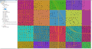
Fire hydrant locations are plotted along the streets in Woodland, CA against a backdrop of map page grids.
The use of GTG consulting services augments the YECA staff and eases their burden of performing these specialized technical tasks, allowing more efficient use of their time. Potential uses abound with this wealth of information. For example, the layers could be combined to produce a report of how many streets or addresses each response area is serving.
YECA’s foresight in developing a systematic approach for updating public safety data has far-reaching benefits. Having up-to-date street and address data allows more reliable location retrieval outcomes in CAD, which may result in time savings for dispatch when seconds count. With this monthly data refresh, YECA can dispatch to new streets soon after they are opened, avoiding the need to look up a caller’s location using other, more time-consuming, methods. GTG looks forward to providing GIS consulting services to YECA through 2021 and beyond.
—————–
To learn more about GIS consulting services from Geographic Technologies Group, please feel free to reach out. You can speak to our team by calling 888.757.4222 or emailing moreinfo@geotg.com.


